Author: THALES
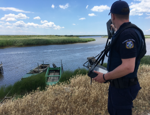
A collection of analytics modules and services has been developed and improved in EFFECTOR project. The goal of these modules is to help the decision making of the End Users enhancing situation awareness, reducing the number of information to be shared between different systems and increasing the global coherence of the information shared.
These modules and services analyze the data in the datalake. Then, efficient mechanisms for querying, processing, analyzing and mining heterogeneous data are used. Finally, the output of these modules can raised alerts to operators if the modules and services detect something abnormal.
Description of the modules
Module Name______________________________________ |
Module short description______________________________________________________________________ |
| InSyTo | This module provides a high-level semantic information fusion tool based on graph data and algorithms. The goal of this tool is to fuse two pieces of semantic information that come from different data sources. Using vessel trajectories from AIS signal, the module is analyzed the trajectories and can detect meeting between two vessels.
______________________________________________________________________ |
| Weak Signal Detection | The goal of the weak signal detection module is to detect patterns that happen on rare occasions compared to normal activity. Using past maritime vessel trajectories, the module, if trained accordingly will detect what could be abnormal trajectories (for example trajectories that look similar to other trajectories but that have enough differences such that they do not correspond to standard cases—with a certain threshold—that would be otherwise hidden away by the vast majority of all the other remaining trajectories).
______________________________________________________________________ |
| TRITON | TRITON is a service which is implemented using a Geospatial Complex Event (GCEP) processing architecture, in order to identify and analyze motion patterns of vessels that indicate an ongoing situation that needs attention. Geospatial complex event processing combines geospatial information and detections from different and distributed sources of information to infer events or patterns that describe the current situation. It offers flexibility in applying rules only in specific areas of interest or in specific vessels according to their type or identifier and it allows to combine rules in order to identify more complex motions.
______________________________________________________________________ |
| Early Collision Notification | The collision notification service will exploit information available from AIS signal to detect, at an early stage, possible collision between two vessels and to generate alarms or alerts based on the severity of the estimated collision risk.
______________________________________________________________________ |
| Recognized Maritime Picture (RMP) |
The Recognized Maritime Picture gathers several vessel information coming from AIS and give support to the decision system, improving efficiency and capability of the forces and the assets. The RMP gives a picture of the activity over a maritime area of interest and further enhancement of response capabilities.
______________________________________________________________________ |
| Mission Planning | The Mission Planning is a useful tool for commanders to manage the staff minimizing the risk of overlapping assets and operators on the field. It provides a comprehensive common operational picture, furthermore, it arranges and enrich situation awareness giving an optimal deployment of the assets.
______________________________________________________________________ |
| Alert and Anomaly Detection | The Anomaly Detection Module provides a tool with an advanced set of clustering, classification and outlier detection algorithms. It uses either simple and advanced heuristics for alert generation or AI algorithms to provide a state-of-art framework for maritime trajectory modelling based on historical databases. As such, this framework is meant to facilitate the learning of vessels behaviors from various features extracted from individual and general maritime positions and trajectories.
______________________________________________________________________ |
Focused on InSyTo module
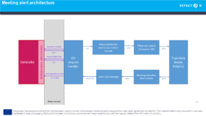
The goal of this data fusion analytic module is to analyze the trajectories and finding weak signal, it can detect abnormal meeting between two vessels. It is connected to the datalake with a webservice. It requests the vessel of interest and the vessel trajectories. Then, the tool converts the data into the Json insyto format, the data is filtered because we do not want to find meeting to close of ports. Then, the trajectory fusion and the meeting detection alert module analysed the trajectories in order to find abnormal meeting. Finally, the alert of a meeting is converted into CISE format and the alert is sent to the datalake. The alert will be display to the operator and can be sent to other partners.